Dzongri Goechala Trek
Area : Sikkim Himalaya
Best Season :
Best Season :
April last week to June end; Mid September to October end. It is
also possible to trek in Nov and Dec but gets dry and very cold.
Max. Altitude : 5002 mts / 16406 ft
Duration : 12 days
Grade : Moderate to Challenging
Duration : 12 days
Grade : Moderate to Challenging
Day: 15° to 25°C. Night: 8° to 15°C. Temp at highest camp, Dzongri: Day 7°C to 15°C. Night: 3° to -2°C.
Temperature in Sept and Oct.
Day: 13° to 20°C. Night: 2° to 7°C. Temp at highest camp, Dzongri: Day 3°C to 10°C. Night: 3° to -4°C.
Rain
Rains start end June until mid September. Approach road landslides/blocks common in late August and early Sep. Usually repaired in a few days.
Snow
Stretch after view point 1 could be under snow in early May. Eases out by June. Light snow cover in Sep/Oct on the higher reaches.
Trek Facts
Easy – Moderate, requires trekking 6 -8 hours each day. Takes 6 - 8 days to complete the trek up till Goechala and back to Yuksom.
Route:
Siliguri – Yuksom – Sachen – Bhakim – Tshoka – Phedang – Kokchurong – Thangshing –Lamuney – Samiti Lake – Goechala View Point 1 – Samiti Lake –Lamuney – Thangshing – Kokchurong – Phedang – Tshoka – Bhakim – Sachen – Yuksom – Siliguri
Rail head:
The nearest railway station is New Jalpaiguri (NJP)which is about 150 km from Yuksom
Road
head:
Siliguri, 140 kms from Yuksom is the major transport hub. You can get shared jeeps and taxis from here. The Sikkim Government buses run to various destinations of Sikkim from the Sikkim Nationalised Transport (SNT) bus station near the Tenzing Norgay Bus Terminus.
Siliguri, 140 kms from Yuksom is the major transport hub. You can get shared jeeps and taxis from here. The Sikkim Government buses run to various destinations of Sikkim from the Sikkim Nationalised Transport (SNT) bus station near the Tenzing Norgay Bus Terminus.
Base Camp:
All arrangements for trek need to be done from Yuksom.
All arrangements for trek need to be done from Yuksom.
Trek Itinerary:
Day 01 : Arrival at Sealdah, Proceed to NJP ~ Train
Over night journey to NJP.
Day 02 : NJP – Yuksom (160 kms/8-10 hrs)
Drive to Yuksom. The base of trek. Dinner and overnight stay in a guesthouse.Day 03 : Yuksam (1785 mts/5854 ft) – Tsokha (3000 mts/9840 ft) (16 kms/8-10 hrs)
The trail from Yuksam starts at the local market and follows main road towards the north. The trail climbs gently out of the valley and hugs the right bank of the Ratong Chu River, which can be heard thundering through the gorge below. The trail crosses over four bridges to climb steeply towards north-west to the small settlement of Bakkhim. Continue for another 3 kms through forest of magnolia and rhododendron to reach Tsokha. On arrival set campsite for dinner and overnight at stay Trekkers hut.Day 04 : Tsokha – Dzongri (4030 mts/13218 ft) (10 kms/6-8 hrs)
On this day the trail passes through the village of Tsokha and continues to climb north through the forest of rhododendron to the alp of Phedang (3650 m) taking around 3 hrs to complete the ascent. Continue further towards Dzongri. On arrival set campsite for dinner and overnight stay.Day 05 : Rest day & Acclimatise at Dzongri
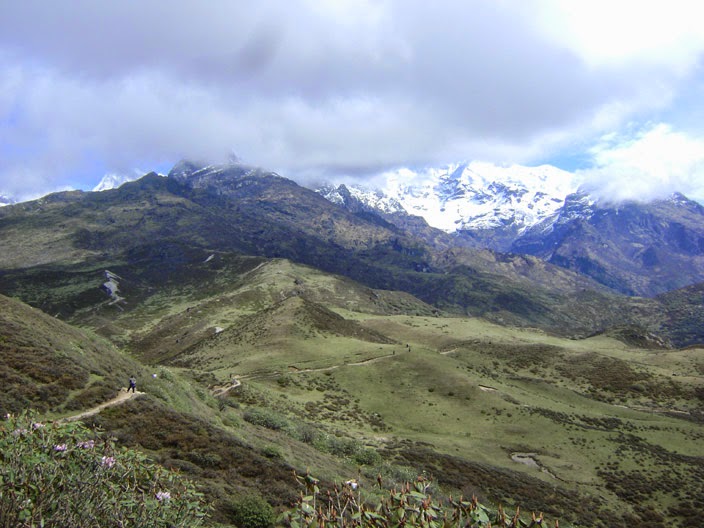
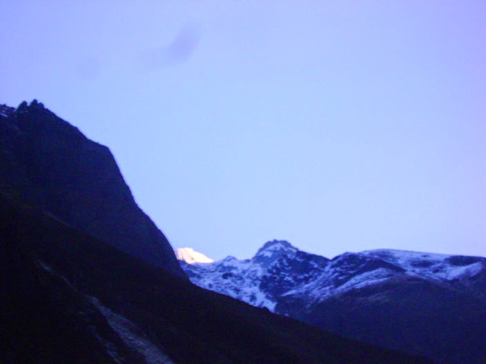
The day is for rest and acclimatization. On this day one can savor views of the mountain peaks by climbing up to Dzongri Top. From here you get a panoramic view of Kabru (7353 m), Ratong (6678 m), Kanchenjunga (8534 m), Koktang (6147 m), Pandim (6691 m) and Narsingh (5825 m). Towards the west, the Singalila Ridge, which separates Sikkim from Nepal, can be seen. Dinner and overnight stay in tents or Trekkers hut .Day 06 : Dzongri – Thangsing (3800 mts/ 12464 ft) (10 kms/4-5 hrs)
The trail from Dzongri continues along the right bank of the river towards east. After cresting the hill the path drops into the valley and then crosses the bridge over the Prek Chu River. It’s an hour climb from the bridge to Thangsing (3800 m) located on the slopes of Mt Pandim. Dinner and overnight stay in tents.Day 07 : Thangsing – Lamuney - Samiti Lake- Lamuney
(4500 mts/ 14760 ft) (7 kms/3-4 hrs)-
The trail from Thangsing climbs gently north and follows a stream and alpine meadows. About an hour above Thangsing we reach Onglathang from where the superb view of the south face of Kanchenjunga can be seen. In order to capture clear views one has to reach Onglathang early. The trail then skirts through a series of glacial moraines before crossing over meadows again, and arrives at the emerald lake at Samiti. Dinner and overnight stay in tents.at Lamuney.
Day 08 : Lamuney - Samiti Lake – Goecha La (5002 mts/ 16406 ft) – Samiti Lake- Lamuney (8 kms/6-7 hrs)
The climb to Goecha La begins with gentle gradient eastwards for about half an hour and then later the steep ascent starts. The trail follows the glacial moraine north-east and then drops to a dry lake at Zemathang. A tough scramble over rocks and boulders with a rise of 400 meters will bring us on the top of the pass. The pass is formed due to the depression between Pandim and the Kabru spurs. It over looks the Talung Valley and commands a very impressive view of the south faces of Kanchenjunga. Afternoon return to the lamuney. Dinner and overnight stay in tents.Day 09 : Lamuney – Tshoka (14 kms/6-7 hrs)
Start retracing steps towards Thangsing will take about couple of hours or so. From Thangsing follow the trail to Kokchorung (3800 m) which is a good camping site. Continue descending towards Tshoka by going through a bypass route directly to Tshoka. Dinner and overnight stay in tents.Day 10: Tshoka – Yuksom (16 kms/5-6 hrs)
Retrace steps towards Yuksam on the final day of the trek. The going is easier as the path is mainly downhill. Overnight stay at guest house.Day 11 : Yuksom – NJP (160 kms/8-10 hrs)
Train
Day 12 : Sealdah at morning
Sweet Home

Preparation
Physical preparation mandatory.
Physical preparation mandatory.
Minimum Age: 10 years
Past experience in trekking: Useful but not essential.
Fitness required: You need to be in good physical condition before the
start of the winter camp. You should be able to jog 4 kms in 30 minutes before
commencement of the trekking expedition.
A word on fitness. The Winter camp involves trekking
on snow and skiing during harsh winter weather. It takes you to a high altitude
of 12000ft when walking on heavy snow. At that altitude the air is
thin and the conditions difficult.
Guide - Purba (Rs. 700/-
per day)
Contact Number - +919593880515
Contact Number - +919593880515
Porter - (Rs. 350/- per day)
Yakman - (Rs. 400/- per day)
Important Information
------------------------------
** Guide, Porter and Mule/Yak/Dzopkey may ask for 2 extra days charge, confirm that while settling.
** Some young guys in Yaksom market place demand themselves as guide. But we found some team, who faced problems taking these young guys with them. Generally these guys are not registered guide but porter, have lack in communication skills and don't have enough experience to deal the odd cases.
** Check your ration every day. Ration shortage is a common problem in this route. Always show and get checked your ration list and quantity by your guide.
** If you want to stay in Huts and don't have hut permits, ask your guide to arrange, it can be done without prior booking but subject to availability.
** You need to report local
police station,how much people is in your squad.You need to submit xerox copy
of voter id card, 1 copy of recent photo.
** Secondly you need to take permission from forest offiice of sikim government. That needed few money
** Secondly you need to take permission from forest offiice of sikim government. That needed few money
** Although the trek starts from the market area,
the trail then goes along the outskirts of Yuksom. You will get your
permits at the KNP check-post on the way. It hardly takes time to get
one.
** As I scramble up with renewed energy, the sight
that greets us is stunning. Deorali is a long flat plateau. In front of us
are yelow rhododendrons on all sides and beyond them is a stunning vista
of awe inspiring peaks glistening white in the sun as the clouds weave in
and out. The chill wind whips along the plateau as we watchthe clouds race
past and dip under and over the majestic Himalayan range.
** The Dzongri trekker hut is also pretty cosy and
there is a restaurant here for tongba and food if needed. There is also a
shop that stocks on biscuits and chocolates and cigarettes. However the
toilets are sadly something else wooden blocks with a hole in the ground
where you pile your "refuse" on top of everyone else's
** Lamuney does not have a trekkers hut and only
has a kitchen which trekkers have to share with the cooks/porters if they
do not carry tents.


No comments:
Post a Comment